Race Report - Stage Coach 400 - Ian Murray
This year’s route was really 374 miles...
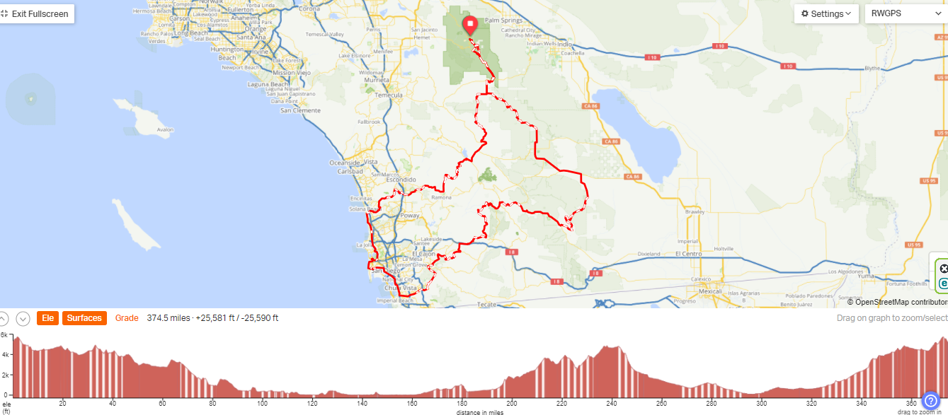
after being altered multiple times due to a very wet winter/spring in Southern California. The race begins at 5,400ft in Idyllwild, a small mountain town east of Los Angeles and above Palm Springs. The counter-clockwise, mostly dirt loop begins heading south east for about 110 miles to the beach at Del Mar. Even though that leg of the race brings us down to sea level it requires over 10,000 feet of climbing to arrive on Pacific Coast Highway. The next sections, about 45 miles, stands out because it’s 100% pavement south through Torrey Pines, the campus of UC San Diego, Mission Bay, the airport, downtown San Diego, and finally Chula Vista before turning east, then north-east. Then we start what is essentially a 70mi climb to the 2nd highest spot of the race – Sunrise Highway at 4,800ft, before dropping down into the Anza-Borrego Desert. After that it’s all sand and uphill to get back to Idyllwild. You can see lots of details of the route here: https://ridewithgps.com/routes/42299393
PIC #1 (RidewithGPS map)
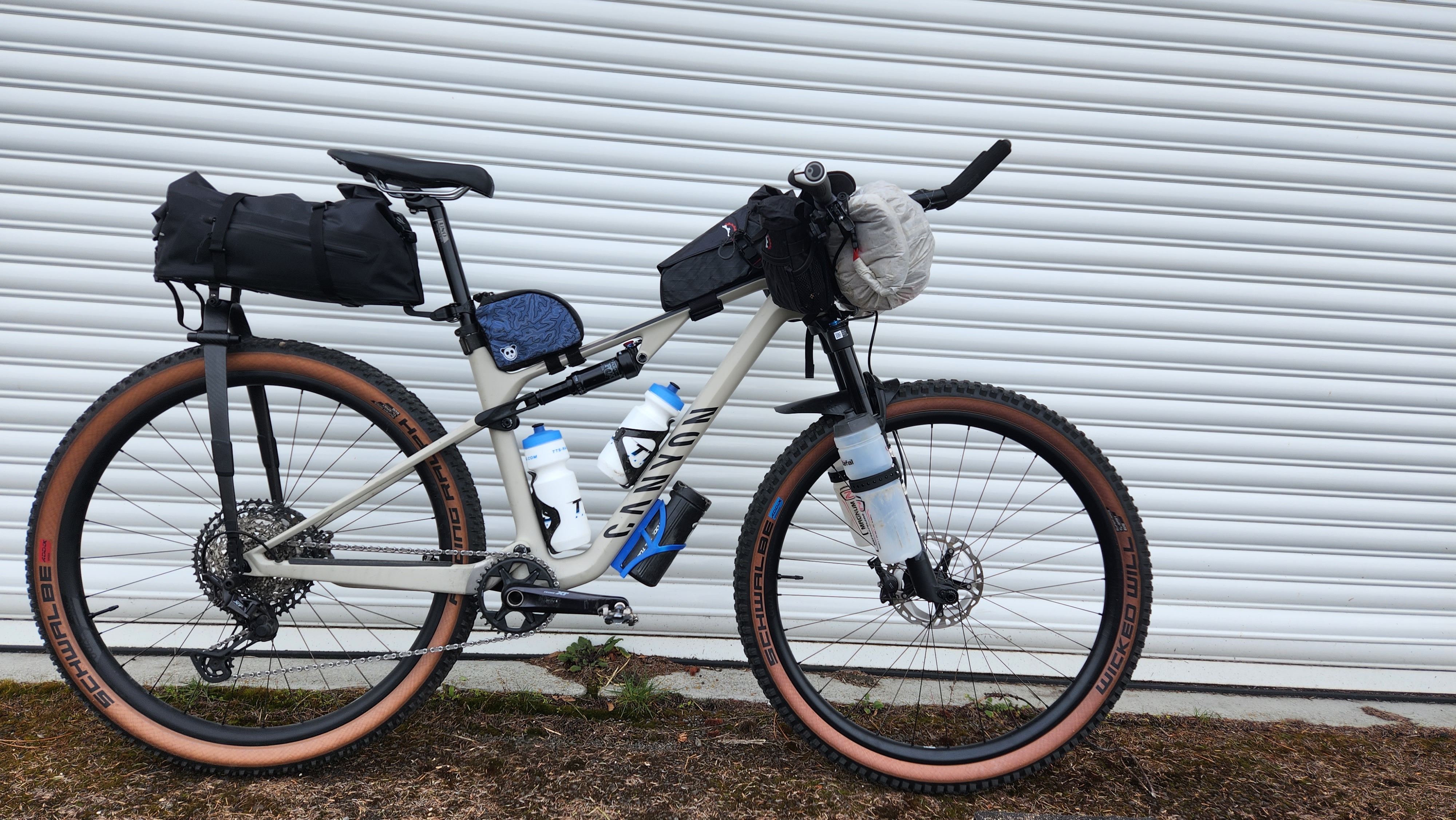
I rode this last year on a rigid gravel bike with 2-inch-wide tires. That bike was great on the paved bits and light on the climbs but didn’t work as well on the chunky descents or deep sand sections. This year I chose a dual suspension mountain bike with 2.4in tires and it was great on the rocky descents and floated better on the soft sand but felt super heavy on the climbs – and, this sounds crazy, but there are ~50 places where you have to lift the bike up over stuff and – this year – a couple of spots where you had to lift the bike over your head and… it was a lot.
PIC #2 (the rig)
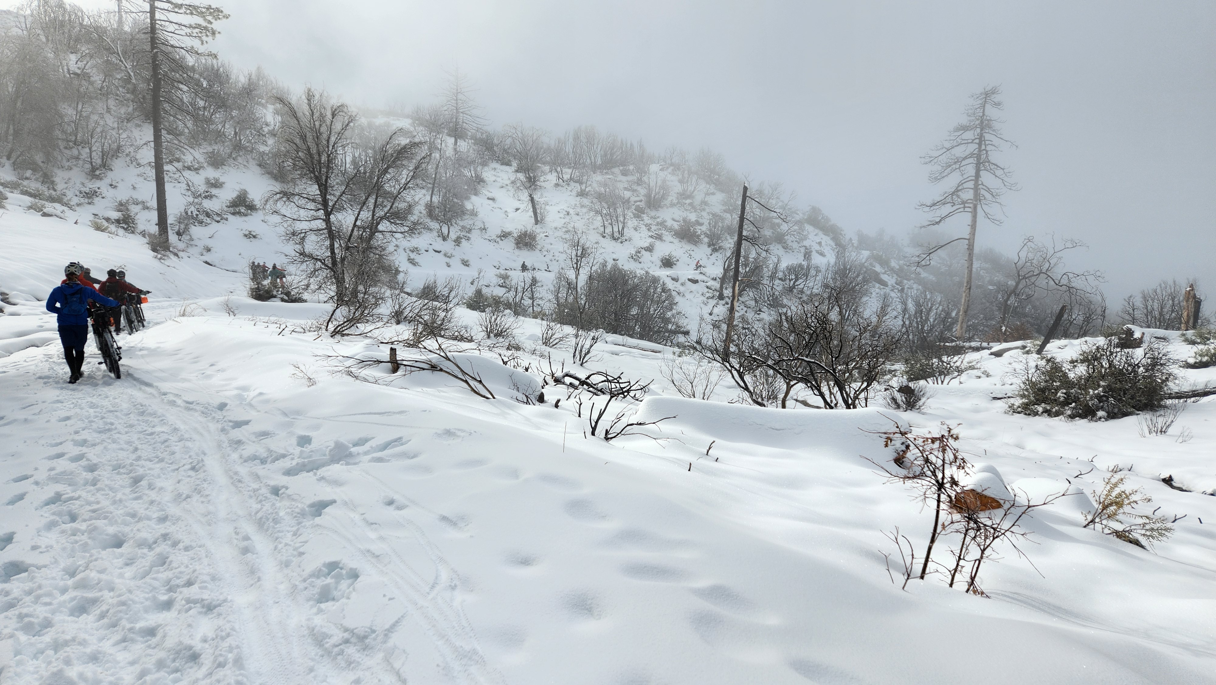
The start this year was special. Idyllwild had received a blanketing of new snow the night before and we spent the first 2 hours pushing our bikes both uphill and downhill through the 12+ inches of snow.
PIC #3 (Snow Fog)
The drop in elevation and the warmth of the morning resulted in melt and mud. The super wet winter has caused the erosion of what used to be a road shown below. This pic really strikes me because I came up through this very part of the route 55 hours later, in the dark, and spent about 20 min in this very spot trying to figure out how to navigate around this canyon – a then even larger chasm – to find the route.
PIC #4 (Snow Sun)
It was beautiful.
PIC #5 (beautiful)
The moisture in So Cal this spring is unusual, and we crossed ~150 creeks, streams, and rivers such as this one below that required us to carry our bikes while we balanced ourselves on a narrow, slippery log.
PIC #6 (River Crossing)
The water was everywhere and in many cases being “on route” meant riding in the creek, in the river. My feet were wet for three days.
PIC #7 (Ride the Water)
I took only two pics the whole ride (the first 2 snowy ones above) all the rest are lifted from posts on the event’s FB page and some youtube video I found. After 4 hours on Friday when we were all hiking through the snow together I had only a little bit of interaction with other races – mainly a Swiss national named Sarah Didier who now lives in San Diego. Look at how she’s dressed here: shell over long sleep jersey, neck gaiter, full gloves, tights, plastic bags in her shoes – it was cold almost the whole ride, and there were MANY descents when I had on every layer with me.
PIC #8 (Sarah D Dressed Warm)
Friday I managed to ride 16 hours, ~130 miles, 10,000 feet of gain, and at 12:30am I called it a day. I rolled out my sleep system in a cover of sage on the edge of the Torrey Pines Golf Course near Del Mar. I slept ‘til 3:30am and then got after it to start Saturday. It think it’s critical to get through the stop signs, lights, etc of San Diego before 6am.
Around 7am I went two blocks off route to have breakfast at an IHOP in Chula Vista and then started the big climb up and over into the desert.
To see this climate so green was thrilling…
PIC #9 (Green Climate)
There were only a couple of hours on Saturday and a couple of hours on Sunday where it was warm enough for me to get down to shorts and a summer jersey. The rest of the time I was in cycling tights, long sleeve base layer & long sleeve jersey with lots of add-ons when needed: gloves, wool hat, shell, neck gaitor, etc. etc.
PIC #10 (me-in-shorts)
I made it to Sunrise Hwy around 8pm, it was dark, foggy, windy, and cold. The dual suspension mtb was so great on Oriflame, the gnarliest descent on the ride and the beginning of the entry to the desert. Around 10pm I rode past another rider who was asleep on side of the road – the ONLY participant I saw the entire day. Once off of Oriflame (and yet, another river to ride through at the bottom) I made it onto some pavement at the edge of the desert. I was going downhill with a tailwind at ~25mph and it was perhaps 53 degrees, 10 degrees warmer than it had been on the ridge above just an hour ago. I pulled into Butterfield RV Park to get some water out of a spigot at ~11pm. This was my first resupply in 40 miles and ~6 hours earlier, and I was near empty. I wanted to push on but an hour later, near midnight, I simply couldn’t keep my eye’s open and pulled off in the desert to sleep for another 3 hours. Day 2 was ~140 miles, 13,000ft of gain, and 21 hours.
There’s a section of the course that few talk about and I need to come to terms with… it starts at mile 267…it’s all sand and lasts 25 miles. It includes something call the Mud Caves, a 4 wheel drive playground called Diablo Drop, and ends with Fish Creek Wash. I find it VERY hard. It’s pretty flat but the sand can be so deep that you have to push, there’s lots of on-and-off the bike, some moments of tough navigation, and when it’s ridable it’s mostly washboards under your already super sore saddle contact bits. I wanted to get this done at the end of day two, but I was cooked and slept right at the begging of the sand. When I woke at 3am I stayed in my bag for a bit, had a super caffeinated drink (Yerba Mate) and a raspberry oat-bar that I got the previous afternoon in some bakery in Alpine. I just watched the stars, listened to the wind and waited for my now dry bibs and base layer – that I had just pulled off a bush - to warm up in my bag with me before putting them on. It was a nice 15min psych session to get ready for this chunk of sand and it went by pretty well. A lot of it looks like the pic below.
PIC #11 (Sand-Seg-1)
After exiting that sand section, I was on pavement, in a head-wind, and pushing towards a breakfast burrito in Borrego Springs – the penultimate resupply before the finish. Right around mile 304 I came upon 14 year old Eden Teitge. He’s from Hayley, Idaho (outside of Sun Valley), his dad was bird-dogging him a bit on this ride and was there beside Eden outside of the family Prius. Eden had flatted and they only had a 27.5 tube for the 29ner – that never works. I pulled my only spare and handed it over with just a moment of hesitation. I need to bring 2 next time. Eden and I leapfrogged each other for the next few hours. He seems like a nice kid – certainly living an unusual life. It’s interesting to contemplate the differing perspective that he might have compared to a classmate who’s putting as much time into TicTok make-up videos as he’s putting in on the bike, isolated in wilderness.
PIC #12 (Eden)
The flowers in the desert were exploding!
PIC #13 (flowers)
There’s a famous section of this ride in Coyote Canyon – it’s called the Middle Willows. Basically, there’s a spring in the desert that flows for a couple of miles as a stream and around that is dense growth. The route – of course- goes right up the stream until it’s blocked by something huge then we have to hike around that. This happens a dozen times in just two miles. Organizers/volunteers spends days in here before start cutting away just enough so that it takes 2 hours to get through this 2 mile section rather than what would be 10 hours. It’s easy to lose the trail and times, hit a dead-end, and have to back-track to find the way. I did that on three occasions and was sitting ~6th at the time. I can’t imagine going through here in the lead with no tracks to follow.
PIC #14 (Willows)
The final re-supply is a tiny, ramshackle store called the Sunshine Market that supports ~40 mobile homes behind it. It’s run by Mrs Singh and highest quality item in the store is a frozen Hot Pocket 18 months past its expiration. Mrs. Singh will nuke that for you, bring it out to the chair outside wrapped in a paper towel and at this point in the ride it’ll be the greatest thing you’ve ever eaten.
The erosion on the final push up to Idyllwild is pretty serious. Climbing even 3-5% with this fatigue means ~3 mph of speed. It’s hard to keep balance over these bits when rolling that slowly and stopping often is required. The endless grit means pedals won’t always release and tip-overs are common. It can be an ugly, clumsy, and bruising way to end a ride.
PIC #15 Erosion 1
There were lots of places where the road just disappears and hiking around in the bush is required to find a re-connection.
PIC #16 Erosion 2
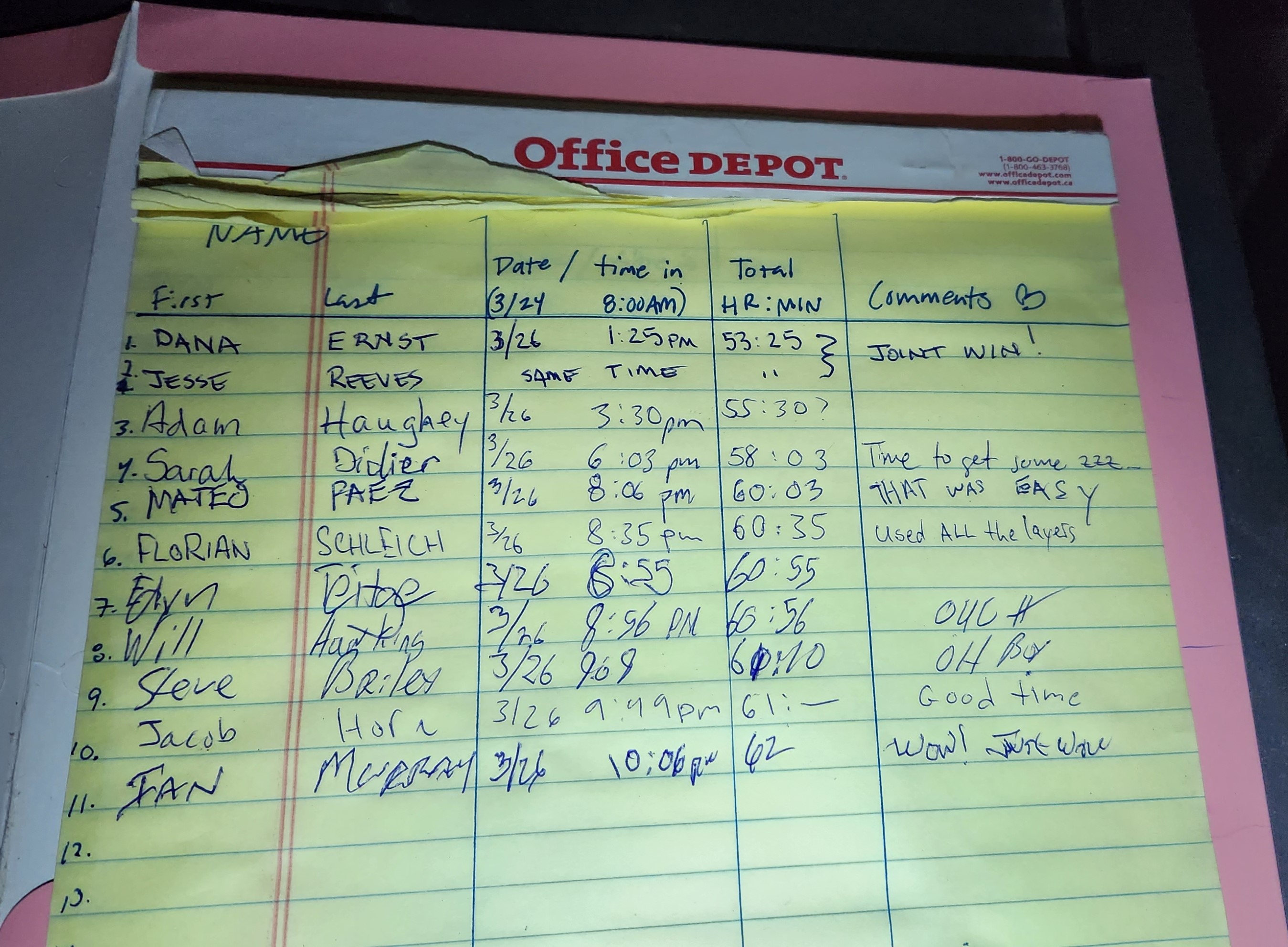
It was 10pm and 30 degrees when I dropped down into the finish on Sunday night back in Idyllwild. I was so cold that my hands could barely complete the course by finding a box hidden outside a coffee house, finding the legal pad inside and writing down my finish. There was no one around, no arch, no fanfare. I had been 6th or 7th with 5 miles to go but some stomach/nutrition issues earlier in the afternoon brought me to a crawl in the evening. As I write this on Thursday, 6 days after the start – 31 finished, 2 are still out on course, and 37 scratched.